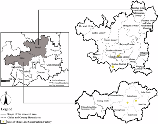
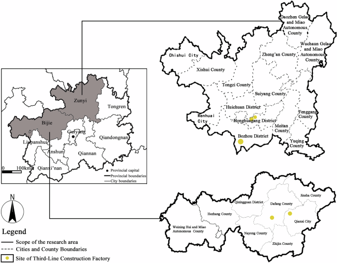
Spatial distribution characteristics of industrial heritage sites in the karst area
Table 2 presents the average dimensional value of the shape dimension of each plant is 1.56, which exceeds 1.5, suggesting that in general, the overall spatial morphological characteristics of the industrial heritage building complex are obvious, the spatial morphological structure is intricate, the plane space is rich, and the building distribution and agglomeration characteristics are obvious. The fractal dimension of the Aviation Site is 1.32, and is below 1.5, which indicates a lower complexity in the texture of the plant, characterized by fragmentation and irregularity, as well as a relatively scattered distribution. The “scattered and hidden” requirements based on the needs of war preparation in the construction process are the main reasons for the spatial distribution of the buildings, and it also indicates that the social background is one of the main influencing factors of the spatial distribution characteristics of the industrial sites. Table 3 illustrates that Guizhou is a representative karst landform area where the industrial sites are located. And it can be found from the overall spatial layout map that the arrangement of the buildings is harmoniously integrated with the natural mountainous and aquatic environment, which has significant terrain dependence characteristics, suggesting that the natural environment serves as the second primary influencing factor on the spatial distribution characteristics of industrial sites. Furthermore, the greater the number of natural mountain barriers in spatial layouts, the more pronounced the isolation effect on settlements, resulting in sparser spatial network structures. However, increased scale and density of built environments can attenuate the overall impact of mountainous isolation. Additionally, building layout patterns in remote mountainous areas tend to be more regular and orthogonal, whereas those in proximate mountainous regions exhibit a combination of organic flexibility and structural adaptability.
Spatial connectivity characteristics of industrial heritage sites in the karst area
Overall Network Completeness: Table 4 shows that the network density of industrial heritage is relatively low, and the connection between nodes in the overall network is insufficient connectivity. Notably, the Zunyi Titanium Plant exhibits the lowest network density. Comparing the layout forms, it is found that the connection between buildings is affected by the natural mountain partition, indicating that the karst topography has a great influence on the connection between buildings. Generally, most of the nodes in the spatial network of industrial heritage areas can be connected through 3 to 6 intermediary nodes, and the value of agglomeration coefficient is not significantly high and remains relatively uniform, suggesting that the overall network completeness of the industrial heritage is not high. Further analysis reveals that the decentralized layout strategy under war-preparedness contexts and limited functional diversity are the primary factors contributing to the insufficient completeness of the system. Comparative analysis with Table 3 further indicates that settlement scale exerts a significant positive correlation with completeness.
Overall Network Vulnerability: Table 5 shows that the overall network vulnerability of industrial heritage networks in karst regions is notably high, as evidenced by Table 3, spatial segregation induced by mountain barriers emerges as the predominant driver of network vulnerability. Among these, the tangential point of the Aviation Site accounted for 2.71%, representing the lowest level of vulnerability, and indicating that the national defense industrial heritage in the context of war preparation prioritizes the security of space connectivity. An analysis of the tangential characteristics of the Aviation Site reveals that the tangent points related to residential land attributes account for 90%, underscoring the significant role that residential buildings play within the overall network dynamics. Furthermore, as depicted in Map of Tangential Points of the Aviation Site (see Table 6), twelve nodes—specifically 1172, 1129, 818, 537, 372, 96, 215, 199, 1136, 346, 502, and 1048—emerge as key points of the external connections of the network group. These nodes exert a substantial influence on network vulnerability, indicating that the criticality of location is one of the keys to the important role of these buildings.
Overall Network-level Stability: Table 7 shows that the edge correlation degree of Qianxi Machinery Factory, Zunyi Alkali Plant, and Aviation Site exhibits a difference of approximately 10%, and the stability is poor. In contrast, the edge correlation degree of Zunyi Titanium Plant is 4.33%, demonstrating the highest stability in network structure. Compared with the spatial network structure of Table 2, it can be found that the spatial network structure of Zunyi Titanium Factory is characterized by clustering, and compared with other industrial heritage sites, the internal network relationships within Zunyi Titanium Plant are notably closer. This observation suggests that the more compact the network form, the denser the network connection, and the more stable the network relationship. Additionally, it implies that natural partitioning serves as a primary factor contributing to this stability.
Overall Network Balance: Table 8 shows that the overall network degree centrality of the third-line construction industrial heritage group in Guizhou is not relatively high, reflecting weak concentration and balance among the building communities. Qianxi Machinery Factory exhibits the highest central potential at 4.43%, characterized by the most unbalanced spatial distribution. In contrast, the Zunyi Titanium Factory demonstrates the lowest central potential at 1.21%, with the most balanced spatial distribution. Compared with the overall spatial layout of Zunyi Titanium Factory, it can be found that the spatial layout of Qianxi Machinery Factory is not compact and divergent, which also indicates that the influence of topography and distribution causes its resources to be unfavorable, and the single-centralized development is the main reason for the imbalance of the spatial network of decentralized land use.
Analysis of Individual Network Competitiveness: From Table 9, it can be seen that the third-line construction industrial heritage in Guizhou can be categorized into five levels based on the competitiveness intensity of its individual networks. Notably, there are few nodes characterized by high competitiveness and high-competitiveness buildings, while the most medium- and low-competitiveness structures. The higher the competitiveness, the higher the effective scale and efficiency of the individual network, and the lower the limitations. According to the proportion of medium and high competitiveness nodes, the following ranking can be established: Zunyi Alkali Plant, Zunyi Titanium Plant, Wujiang Power Plant, Qianxi Machinery Factory, and Aviation Sites. This analysis, combined with Table 10, suggests that the layout of industrial heritage is relatively compact and smaller in scale, with a greater proportion of high-competitiveness building nodes, whose configuration is advantageous for enhancing the significance and connectivity of building nodes within the network. Furthermore, as illustrated in Table 9, building nodes with high and high competition values are predominantly located in the center of the settlement or at intersections, rather than being confined to specific areas, indicating that location and traffic are the key to the development efficiency of building nodes. Additionally, the high competitiveness values of building nodes surrounding those with significant competitiveness is also high, suggesting that the development advantage and network connections have a driving effect.
Analysis of Individual Network Role: As illustrated in Table 11, the same building can simultaneously fulfill multiple functional roles within the spatial network, and the more functional roles it plays, the more important the node is. Predominantly, nodes that exhibit a greater number of functional roles are situated at intersections or along three-sided ring roads, and the buildings are located in the central area of the nearest group, indicating that location and traffic are the key determinants to the realization of roles. Among all functional roles, the coordinator role constitutes the largest proportion, indicating that a majority of the subgroups possess building nodes with high influence on the logistics and information flow within their respective subgroup network. Notably, the functional role value of the Zunyi Soda Plant represents 10.27% of the overall network, marking it as the highest proportion. This finding underscores that the subgroup of Zunyi Soda Plant has the best internal connectivity, and also suggests that a smaller building scale and a more compact the layout result in a greater number of nodes with functional roles.
Strategies for the protection and utilization of industrial heritage
Holistic Protection and Systematic Restoration of Industrial Heritage: The spatial pattern of industrial heritage reflects the distinctive features of industrial culture, encompassing aspects such as industrial production process, organizational and managerial structure, the integration of production and daily life, and regional environment, which is the precipitation of industrial culture within a spatial context26. The spatial pattern of industrial heritage is mainly composed of clusters of buildings, transportation space interconnected by these clusters, and activity squares. Consequently, the preservation of the spatial pattern of industrial heritage entails safeguarding the relationships among these building groups. In the construction of some industrial heritages, there is a low level of environmental quality and the phenomenon of “messy and dirty” buildings, and traditional preservation approaches, characterized by the notion of “freezing” and the prevalent practice of the old to its original state, are not entirely suitable for the transformation of industrial heritage27. Therefore, it is essential to consider these transformations on the basis of taking into account the relationship between spatial networks. Firstly, the characteristics of spatial distribution in industrial heritage settlements must be preserved, that is, “spatial distribution in alignment with the topography and social context”, specifically protecting the organic relationship among nature, architecture, and space. Secondly, systematic protection and restoration should be implemented based on the quality and function of existing structures, emphasizing the extraction of the existing building’s texture. New constructions should conform to the regional architectural scale and the mechanical characteristics of the surrounding area, where structures in remote mountainous regions tend to exhibit more regularity, while those in closer proximity to mountainous areas display greater freedom in design. Finally, it is imperative to restore the spatial network relationships by enhancing transportation connections, thereby reducing the spatial segmentation of buildings. This approach aims to improve the stability and balance of the overall spatial network.
Hierarchy and Classification Protection and Utilization of Industrial Heritage Buildings: In light of the high-competitiveness distribution buildings in the individual network, and considering the interrelationship among the components such as the history of industrial heritage and the historical industrial processes, as well as the industrial production lines and industrial nodes in the building, the important protected building complexes are delineated. The components closely associated with the industrial processes are categorized as part of the environmental coordination building group, taking into account the distribution of less competitive buildings within the individual network and the integrity of the industrial style. The buildings that comprise the important protected complexes are designated as key protection levels, wherein alterations to the architectural style are prohibited, and destruction or demolition of these structures is not permitted, with the protection of the original historical elements and cultural display as the leading function. Conversely, the environmental coordination building complex is classified under a general protection level, allowing for the construction and renewal shall be allowed, provided that such activities align with the environmental landscape and the original architectural framework. In conjunction with the location of the building in the spatial network relationship, the level of industrial heritage activation and utilization is delineated. It is evident from the preceding analysis that the more functional roles played in the spatial network relationship, the more important the nodes are. Specifically, the buildings with more than three functional roles or network tangent points are identified as critical nodes within the region, representing the core of the activation and utilization of the entire industrial heritage. Conversely, buildings with one to two functional roles are classified as important nodes, serving as centers for the development and utilization of the surrounding building groups, while the remaining buildings are categorized as general nodes.