
The Department of Water Resource’s Basin Characterization Program provides the latest data and information about California’s groundwater basins to help local communities better understand their aquifer systems. One of the technical assistance projects under the Basin Characterization Program is DWR’s Statewide Airborne Electromagnetic (AEM) Surveys.
As a part of the AEM project, DWR is conducting AEM surveys in California’s high- and medium-priority groundwater basins, where data collection is feasible. The collected AEM data assists local water managers in characterizing their aquifer systems and supports the implementation of the Sustainable Groundwater Management Act (SGMA) to manage groundwater for long term sustainability.
The AEM project provides state and federal agencies, groundwater sustainability agencies (GSAs), stakeholders, and the public with basin-specific and cross-basin geophysical data, tools, and analyses.
The surveys are funded by voter-approved Proposition 68, Senate Bill 5, and from the general fund. More information can be found in the AEM Proposition 68 Fact Sheet.
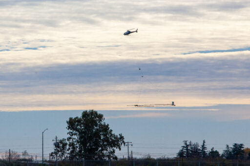
During an AEM survey, a helicopter tows electronic equipment that sends signals into the ground which bounce back. The process has been compared to taking an MRI of the ground’s subsurface. The data collected is used to create continuous images that are interpreted for underground geology.
The resulting information provides a standardized, statewide dataset that improves the understanding of aquifer structures. It can also help with the development or refinement of hydrogeologic conceptual models and can help identify areas for recharging groundwater. See the publication below for an overview of the Statewide AEM Survey Project and a preliminary analysis of the AEM data.